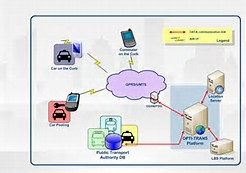
In English, this is known as an Indoor Based Positioning System or Location Based Service. It is commonly referred to as a navigation system within closed buildings or structures. All of us use GPS or navigation systems on our mobile phones… But have we ever wondered just how—by what process—the GPS carries out this function? Let me briefly introduce the method. This process is called Trilateration. In the language of technology, it is a geometric approach. Let’s learn what this means. Scientifically, and especially mathematically, it’s quite simple. We are all at least somewhat familiar with what a circle is. In the Trilateration method, circles play a key role. Essentially, the signals sent from satellites to our mobile phones are converted to distance using their power levels in this system. Then, considering the satellite as a reference point, the calculated distances are used as radii to draw circles. Geometrically, the intersection points of these circles, typically centered on three satellites, indicate the position of our mobile phone’s GPS. It’s important to note, however, that the satellites’ movements and velocities significantly affect this process. Additionally, research and experiments suggest that this method does not always produce satisfactory results. Therefore, the A-GPS system is often used as a supportive measure, delivering more reliable results for determining our exact location. However, it should also be noted that GPS generally provides accurate results only in open spaces. When you or I enter a closed space with our phones, the GPS system will no longer work properly. This is because there is a need for an LoS (Line of Sight) system between the satellite sending the signal and the mobile device in our hands. The LoS system requires that there be no obstacle (a wall, for example) between the transmitter and the receiver at the time of signal transmission. As soon as any obstruction appears, the system will not be able to deliver the expected results. Generally, because the LoS system can’t function properly in enclosed areas, the concept of the Indoor Based Positioning System gradually emerged. Scientists began to consider alternative ways to accurately determine one’s position indoors. Here are a couple of the main reasons behind this development. With time and technological advancement, people now want everything at their fingertips. In modern shopping malls, for example, there are thousands of brand outlets. People have always been brand-conscious. Finding a specific brand’s outlet on a particular floor in large shopping malls can be quite challenging if you don’t already know its location. Or let’s say you are traveling to another country. We are all somewhat familiar with the concept of transit during travel. Navigating an unfamiliar airport in a foreign country with an unfamiliar language to find your desired location is no easy task. In such cases, if your mobile phone could help you easily find your intended place, it would greatly reduce your hassle. It’s such small considerations that sparked the beginnings of this sector. Over time, various studies have introduced us to newer and newer systems in this field. One such system is known as RF Fingerprinting. Upon hearing the name, many—like you and me—might wonder if this involves using fingerprints from our hands. In reality, this system has nothing to do with fingerprints. Instead, it works by utilizing radio frequencies. Let me try to explain this in a bit more detail, though I don’t know how well I’ll be able to describe it. In this system, a closed space is first divided into segments at regular intervals, with efforts made to keep distances between divisions as small as possible. Then, at each segment’s endpoint, the power of received radio signals is measured every 5 seconds for a duration of 1 minute, and these data are recorded into a database. While recording the data, it is useful to assign names to each endpoint for ease of future work. The device used for recording this data is called TEMS. It is capable of recording about 1200 data points per minute. It’s important to note some aspects about radio signals. The power of any electromagnetic signal depends heavily on the surrounding environment—noise from people, the position of the receiver’s antenna, environmental dryness, and obstacles like walls all greatly affect any electromagnetic signal. Obstacles such as walls, in particular, have a strong impact, which is precisely why GPS systems cannot perform accurately indoors. To account for different obstacles, the data are typically recorded at five different times—such as morning, noon, evening, night, and during periods of heavy human activity. Afterwards, the KNN algorithm is used to process the rest of the data. When someone moves through the enclosed space with a mobile device, the phone records the power of the signals it receives, compares them with the data in the database, and—with the help of the algorithm—determines the exact position of the person. Essentially, this is how we can locate someone in a closed area using this method. However, it is important to note that this system is quite expensive, which is why it has not yet become popular in developing countries. But as various mobile companies show increasing interest in this sector, it’s not long before we’ll have this technology at our fingertips. Current research is mainly focused on finding alternatives to RF Fingerprinting. To be specific, today’s research aims to find ways to use the Trilateration method indoors, determining accurate locations in the simplest manner possible without the need to build a database.
কিভাবে কাজ করে?
 shayokhAugust 21, 20134 Mins read
A New Approach to Tracking: Indoor Based Positioning System


Related Articles


Leave a comment